The Roman castrum of the 13th Gemina Legion

COD LMI: AB-I-m-A-00001
Date of construction: sec. II-IV
The defense system: components and characteristics
After a first construction phase in the shape of a rampart (castrum estivum), which was elevated after Dacia was occupied (in 106 A.D.), the castrum of the 13th Gemina Legion reached a second, stone phase (castrum stativum) approximately half a century later (at the end of the reign of Hadrian in 138 A.D. and the beginning of the reign of Antoninus Pius). The castrum existed actively until the army and the Roman administration left the province (271 – 275 A.D).
A summary presentation of the form, the dimensions and the on-field location of the castrum, listing the elements composing the defense system and the manner in which they are laid out, as well as the organization at the interior, reveal the importance and the characteristics of the military camp founded and organized by the Roman soldiers and officers in Apulum.
Having an East – West orientation, the quadrangle shape of the new fortification shows in the route of the stone walls with approximately equal sides (480 x 432 m), marking an interior surface of approximately 20.7 ha.
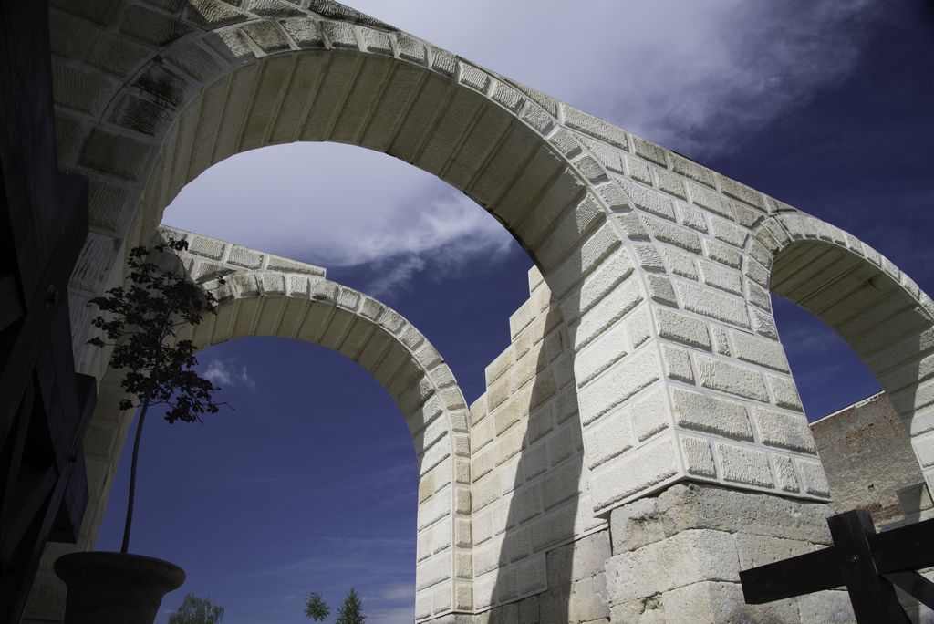
The main elements composing the curtain wall aimed to comply with strict rules of lagging from the outside towards the inside, with the following components: the moat, the berm, the stone wall, the rampart and the patrol path.
The moat (fossa in Latin)
The wide and deep moat represented the first exterior obstacle built at a certain distance in front of the wall, the width of the berm being variable. Three of its sides were immortalized and displayed a reversed trapezoid shape, with a variable inclination of the slopes and a straight base (dimensions: 7 m at the crest; 2.5 m at the base; 5-6 m deep; 5 m wide berm).
Stone walls ("murus" in Latin)
The main de fense element of the castrum was the wall built of massive stone blocks excavated from the quarries in Şard, Ighiu and Ampoiţa, profiled and laid out in two rows connected by filling (emplecton).
The dimensions of the walls seem impressive (7 m high; 2.10 m thick; 2.15 depth of foundation). The wall is perforated on each side by ample openings hosting the access gates, with towers in the corners and curtain walls and pinnacles in the superior part. The precinct wall is the main element of the defense system of the Roman castrum, being partially preserved within the defense structures of the old medieval fortress until the 18th century. It can still be seen today on some segments of the wings, at the South or included in the foundations of medieval buildings (the Episcopal Palace, the area of the former security printing office).
The Towers ("turris" in Latin)
The existence of defense towers in the 13th Gemina Legion castrum can be proven by the towers flanking the gates, through the surface layers which are preserved at the South gate or the corner towers and through the foundations discovered at the crossroad of the East and West wings. Two more curtain walls were identified on the alignment of the West wing.
The Gates ("portae" in Latin)
The East Gate (porta praetoria) was the mirror of the West Gate (porta decumana – partially identified on Nicolae Iorga Street), both being situated in the middle of the respective wings.
Used to facilitate connections with the outside, the castrum gates were placed symmetrically, one on each of the four sides.
The principalis gates – the dextra and sinistra – dividing the castrum into uneven areas crossed the North and South walls, at a smaller distance (1/3) from the East wing. All the gates were equally used, facilitating
the connection with the large Apulum settlement which developed more intensely in the North, West and Southwest, having secondary roads towards Ampelum (Zlatna), Alburnus Maior (Roşia Montană) respectively Blandiana and also an imperial road to Brucla (Aiud), Potaisa (Turda), Napoca (Cluj Napoca) etc.
Uncovered and brought to light almost two millenniums after it was built, the South gate of the castrum (porta principalis dextra) still preserves the structures of the defense towers and the wide opening situated above ground level, with a central pillar for the double entrance which makes it possible to recompose its original shape.
Wide openings (10 m wide), flanked by strong and tall towers (8.40 m x 6.00 m), conferred the gates an aspect of monumentality, their functional role being doubled by an emblematic, triumphant message.
The Rampart (agger)
It was only discovered on the South wing, so it probably orginates from the first phase of construction - the earth castrum. It is possible it was also employed in the second phase, with the purpose of consolidating the stone curtain wall.
Patrol Path (via sagularis)
A clear, fairly wide space (approximately 8m) called intervallum (intermission between ramparts) usually existed inside, around the curtain wall, with the purpose of protecting soldiers and buildings from possible projectiles thrown over the wall. Sometimes this coincided with the patrol path of the guard formations or it was used for exercises. In the case of the Apulum castrum, the soldiers’ road went through two construction phases, being created at different levels and with different materials (a first stage in which it was built at a lower level and was enhanced with gravel and a second phase when it was placed higher and built of stone slabs).
The internal organization of the castrum
Communications paths had the determining role in the organization of space inside the fortification, both from the point of view of importance and from the point of view of orientation.
The wider roads (8-10 m) connected the four parts or divided the surface inside in large, well-defined areas, while the narrower alleys (2-4 m) created the necessary intervals between the buildings, at the same time facilitating the movement of troops and the guarding of the objectives.
Via principalis was the main road which crossed the castrum laterally with the purpose of creating a North-South connection between porta principalis dextra and porta principalis sinistra. An Eastern area of the castrum (the praetentura) was thus created, spreading over 1/3 of the surface inside the fortification, aiming to obtain the necessary space for representative constructions.
Via praetoria, the second important communication road, partially crossed the castrum from East to West, connecting the homonymous gate (porta praetoria) to the headquarters building. Via principalis intersected in front of this building dividing thus the Eastern area into equal surfaces.
Via decumana formed the second segment on the West-East axis, being interrupted behind the headquarters building and dividing the Western area into two equal parts.
This way the central area of the castrum – with the best positioning and defense – was found at the intersection of the main roads, the important buildings in the precinct being grouped here: the commander’s headquarters (praetorium), including the rooms hosting the bank (argentaria), the insignia and the white flag of the legion (signum), the temple (aedes), the food deposits (horrae). Confined by via praetoria and via decumana, bordered and protected by via sagularis, the surfaces of praetentura (East road) and retentura (West road) were reserved to the barracks – the dwellings of military in the elite units and the auxiliary troops.
In the context in which a systematic re-enacting of the organization of the interior surface of the 13th Gemina Legion castrum in Apulum is not possible due to the destruction and the radical transformation occurring along with the reconstruction of the precinct, the value of the components of defense curtain wall preserved until the present (the South gate, parts of the stone wall in the foundations of medieval buildings or those preserved at the surface), the segment of via principalis and part of the principia discovered on the occasion of the rehabilitation of access ways into the Austrian fortress, become invaluable, representing a unique testimony of local historical realities two millenniums ago.
PHOTOS